GEOLOCALIZATION SYSTEM FOR PERSONNEL ON MISSION
INTELLIGENT PORTAL AT THE SERVICE OF ABROAD MISSIONS

Accesso al portale

To facilitate the management of staff and abroad business, Società Servizi Italia (SSI) uses a portal that effectively facilitates the 6 points strategy.
This is the first global satellite system based on Artificial Intelligence (AI) with which SSI takes care of the safety of company personnel on mission. The system relies on a team of expert professionals who develop insights and analyzes through direct observation and listening to “rumors” with the help of local observers in the area, in all countries of the world.
In case of business trips, SSI provides the company with the Country Risk Analysis updated in real time, specific for the entire itinerary up to the local level and takes care of organizing the reception and assistance with international partners, who come to pick up the customer from the airport if requested and appropriate: it is a chain of activities that goes from the initial study to the final management.
The combination of the geo-localized tracking AI system and the human analysis activity, carried out by personnel with specific experience, makes the protection service unique and extremely efficient, so that the company can fulfill all dictates provided by current legislation.
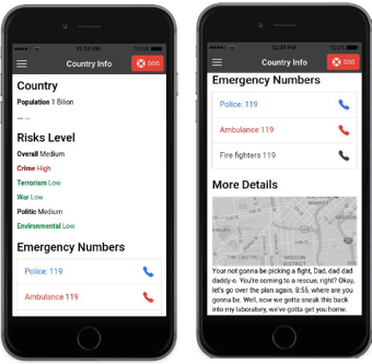
In addition, the RISK MAP service, included in the solution, ensures companies using it to have complete visibility and monitoring of the world map with 7 risk levels for each country. The system is updated in advance of 4 hours compared to the Farnesina with more local detail in the specific area.
The service consists of a WEB platform, accessible with specific credentials, and a self-installing App for Android and iOS.
THE WEB PLATFORM
A supervision dashboard is made available through the WEB platform which displays the devices equipped with the App and the device counters by country on the geographical map.
The risk levels, news and health warnings for each country are displayed from the RISK MAP management panel. The panel allows you to edit and enter new information, which can then generate a push notification on smartphone devices active in that specific country.
Missions and devices are managed from the WEB platform. The user data to whom the device will be assigned are NOT registered. However, there is the possibility of associating a reference ID to an external service. In this way, the GPS positions collected by the system are recorded anonymously and linked only to the devices. For each mission, one or more devices are assigned in which it is possible to enter various information: start and end dates, description, main destination, contacts and useful addresses, etc.
To support the customer, SSI has access to the SOS advanced supervision dashboard, to view the position of the devices that are in SOS status, with information on how to contact them and the device counters by country, the history of the GPS position of the devices in SOS status and the Heatmap of the areas most visited by the device during the mission, in addition to the basic functions.
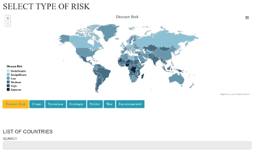
Risk Map
The RISK MAP consists of a world data map which can be filtered and zoomed where every problem (e.g. disease, terrorism, wars, geological and atmospheric events, etc.) is visualized by infographics through shades of blue, depending on the level of risk.
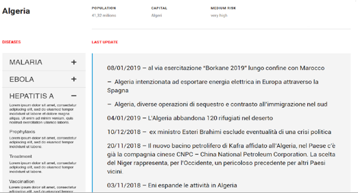
Detailed information
By selecting a country of interest, information can be viewed in detail, starting with a live news section relating to risks and issues.
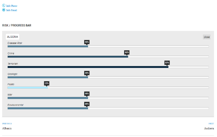
Risks and alarms levels
A “Progress Bar” briefly shows in percentage all the risk categories relating to the chosen country, providing an immediate and easy to read image.
The management panel allows you to define the alarms relating to Geo-Fence Areas, ie the “safety” area for each mission, in order to receive “alerts” in the event that the device sends the position outside the defined area.
Data for each user
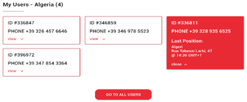
For each selected country it is possible to view an information grid with the main data of each user engaged in the reference risk area.
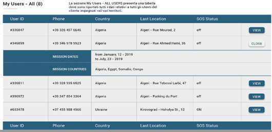
All users overview
Furthermore, it is offered the table where are shown all data relating to all the users engaged in the various territories.
SMARTPHONE APP
The personnel on mission is provided with a self-installing App that communicates with the central platform, equipped with Artificial Intelligence, for combined GSM, GPS and Satellite tracking which makes it immune from the fall of the radio link signal due to atmospheric, geological and human events.
The application collects the GPS position at regular time frames (configurable from the backend) if the following condition is met: the device has been activated and the current date is between the start / end of the mission. In the menu there is a button for sending the position manually and the history of the last position sent.
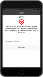
Mission start
User activation is carried out at the start of the mission through a unique code created specifically for the mission itself and for the reference device. This code will have a dynamically set deactivation time.
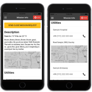
Useful geolocated contacts
Once the mission has begun, the APP shows information with a special space dedicated to places or useful contacts during the entire period of the mission. All this is done using the functionalities of the operating systems, such as the dialer and maps.
Geo-localized risks and information
The APP offers a summary with all information relating the country in which the device / mission is located, such as: short description of the country, risk levels provided by SSI, emergency numbers and a text field for additional information.
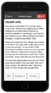
Health warnings
In the event of general warnings or health warnings, the list of Health Warnings is displayed relating to the country in which the mission is active, which can be filtered through the tags associated with the warnings. Tapping on the tabs in the list the detail of the warning is diplayed with: title, complete text, publication date and associated tags.
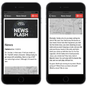
Geolocated news
The user can have real time access to the list of the most relevant news relating the country in which he is located. By tapping on the tabs in the list, the news detail opens with: image, title, publication date, full text and map (if provided).
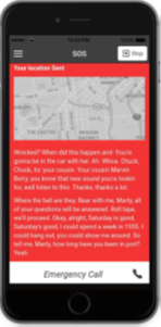
SOS in case of need
Finally, in case of emergency, an SOS can be activated to communicate the coordinates of the current position to SSI. Activating this mode will increase the collection / sending frequency of the GPS position.
PECULIARITA’ DEL SERVIZIO
Specific self-installing app on the smartphone for personnel on mission
Tracking of the combined GSM, GPS and Satellite App which makes it immune from the signal interruption of radio links due to atmospheric, geological and human events and which allows:
- Tracking through the central system
- The automated communication of useful and updated information on the mission (map, vaccinations, local traditions, risks, behaviors to be followed, emergency contacts, etc.), interactive and specific for the entire route and transit areas
- Health risk management: real-time updating with the bulletin of the World Health Organization for the prophylaxis of mandatory and recommended vaccines in order to be able to prepare adequately with the appropriate timelines, precautions and local legislative obligations.
Real-time reports about which and how many people monitored are in each country in a specific time frame (with a simple click).
Frequency of movements statistics report
Access to central monitoring system and RISK Map through a simple portal, without installation of any local application.
Operational and analytical skills of experienced and competent professionals for the management of the central AI system
On-site presence, in every country, of long-time observers in constant contact with the operations room. This allows a better, reliable and timely source of information, to avoid the central operators mere theoretical / statistical analysis on risk situations.
Contact us
+39.02.8252342
MIlano
Centro Direzionale Milanofiori
Strada 4, Palazzo A5
20057 ASSAGO (MI)
Roma
P.le Roberto Ardigò, 30/a
00142 Roma
Tel. +39 06 45442737
Ask for a quote
Fill in the form below by asking us a question or describing your need!
One of our experts will contact you without obligation to provide the requested information!